Forecast: More tornadoes possible
Published 12:38 am Tuesday, April 29, 2014
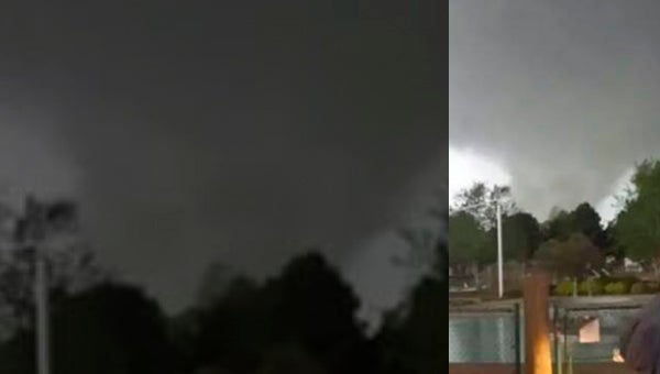
NATALIE HAMILTON | CONTRIBUTED
ANOTHER VIEW: Another local resident caught this image of the EF3 tornado that devastated parts of Beaufort County Friday. Today and tomorrow will bring similar weather, though with less chance of tornadoes, according to National Weather Service meteorologists.
After Friday’s severe weather that birthed an EF3 tornado and a series of sister tornadoes, weather projections for this week have left many eastern North Carolinians concerned for their safety and property.
According to Jim Merrell, the lead forecaster with the National Weather Service in Newport, projected conditions will be favorable for strong thunderstorms.
“Not necessarily the same as what we had with a significant threat of tornadoes,” said Merrell.
Merrell said that Friday’s conditions were especially favorable for tornadoes.
“Friday we had a cold front coming in and low pressure developed further south of north central or central North Carolina,” Merrell said. “That produced just the right conditions for winds to be veering in the lowest few thousand feet of the atmosphere and that allowed the storms to start rotating. When you have strong wind sheer loft and veering wind direction and speed then that can cause rotating storms. We had just the right conditions for that on Friday.”
Today and Wednesday, the weather conditions will be similar to that of Friday, according to Merrell. The big, upper level, low-pressure area, which is currently moving across the central United States, started producing severe weather last night.
“It gradually started spreading a little northeast today,” Merrell said. “In Mississippi, they’ve got tornadoes. That threat will be gradually moving to the northeast today and Wednesday, but it is not exactly the same conditions as we had on Friday. We’re going to have moisture, we’re going to have instability, there’s going to be showers and thunderstorms around and some wind sheer like what we had last Friday, but possibly not quite as strong. There’s going to be threats of some of these storms producing strong, gusty winds and possibly some hail, but I’m not seeing the same exact conditions where we had very strong low-level varying of the winds like on Friday.”
Merrell said that this type of weather is common for the spring season. In the transition from winter through the spring months — March, April and May, especially — it is not uncommon, whenever a strong cold front like that experienced Friday moves in, for strong to severe thunderstorms to form.
“To have an EF3 tornado, that is fairly unusual,” Merrell said. “That is something that is probably only going to happen every few years or so.”
However, according to Merrell, the fact that an EF3 tornado touched down in eastern North Carolina with so few significant storms throughout the Great Plains and Midwest this year, makes Friday’s severe weather unusual.
“Apparently, it was the only EF3 tornado reported in the United States for this severe weather season,” Merrell said. “That is fairly unusual. Usually you get something in Texas, Oklahoma and more through Tornado Alley. It was the first EF3 since the April 2011 outbreak.”
According to Merrell, storm chasers identified Friday’s primary storm cell as far west as Wayne County.
“They were telling us that the wall cloud on several of the storms was well-pronounced,” Merrell said. “The earlier storm that came out of Wayne County, went into Greene County and then northern Pitt County — the storm chasers were chasing that. People were telling us that it was reaching the ground, but we couldn’t find any damage from it. But then we got this secondary cell that developed a little bit south of that track. It came across southern Greene County and northern Lenoir County into southern Pitt County and then really developed. It got strong rotation developing with it and then produced tornadoes that touched down in Pitt County. The strongest one went across Beaufort County in Chocowinity and parts of Little Washington and then to the northeast.”
Merrell went on to say that the notifications that have already gone out for the approaching storm as well as the events from Friday should give residents an idea of what to expect and prepare for in the next 24 to 48 hours.
“People are going to be much more aware of impending weather,” Merrell said. “We have already mentioned that there is a severe weather threat for Tuesday into Wednesday. If you get a watch put out for your area, then you should already have in your mind what you’re going to do if a storm comes up and be prepared to take action with that. We (NWS) are here watching the radar and using all of our tools to put out warnings. Using our Doppler radar, we can see when the storm actually starts to rotate. If we see it has strong enough characteristics, we are going to put out a warning and then we rely on TV stations and other media to help get that word out to the public. Another thing we also use here is the NOAA (National Oceanic and Atmospheric Administration) weather radio and those are very good things to have because as soon as we push the button to issue a warning on the computers, that goes to the weather radio system and if you have one of the weather radios and set it for the alarm feature, it will set off an alarm immediately on your radio. That way you won’t have to rely on a TV or anything like that.”
More News


SportsPlus
How to Watch the NBA Today, December 10
The Dallas Mavericks against the Oklahoma City Thunder is one game in particular to see on a Tuesday…
NBA Spread and Total Picks for Today, December 10
There is a lot to be excited about on today’s NBA schedule, including the Dallas Mavericks taking on…
How to Watch Top 25 College Basketball Games – Tuesday, December 10
The Wisconsin Badgers versus the Illinois Fighting Illini is one of five games on Tuesday’s college basketball schedule…
Best Bets for NCAA Basketball Picks Against the Spread for Tuesday, December 10
The Penn State Nittany Lions versus the Rutgers Scarlet Knights is one of many strong options on Tuesday…
Where to Watch Carolina Hurricanes vs. San Jose Sharks on TV or Streaming Live – December 10
The Carolina Hurricanes (17-9-1) take on the San Jose Sharks (10-15-5) during Tuesday’s NHL schedule, starting at 7:00…
-
Polls
 Loading ...
-
-