GETTING AROUND: NCDOT, Sheriff’s Office sites offer best information on travel, GPS use unreliable
Published 11:44 am Monday, September 17, 2018

- TRAVEL: The Beaufort County Sheriff's Office has shared a travel map to help Beaufort County residents stay aware of potential hazards.
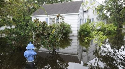
A number of roads and bridges throughout Beaufort County are still impassible in some areas as of Monday morning. Both the Beaufort County Sheriff’s Office and the North Carolina Department of Transportation have made maps available showing the latest conditions of roadways and bridges.
To access the map provided by the Beaufort County Sheriff’s Office, visit https://sartopo.com/m/DU03.
Red = Water in roadways
Yellow = Trees in roadways
Purple = Roadway open
To see the latest on statewide conditions, visit the NCDOT Traveler Information Management System at http://tims.ncdot.gov/tims/.
A statement by the NCDOT on Monday advises that travel is not advised in many parts of Eastern North Carolina.
Due to flooding in southern, central and eastern NC DOT advises motorists not travel through these parts of the state.
Travel should be completely avoided in areas south of US 64 and east of I-73/I-74. Several sections of I-95 and I-40 are flooded. I-95 Southbound traffic from Virginia should use US 64 west (Exit 138) to I-540 west to I-40 west to US 321 south to I-85 south. Follow directions in South Carolina to re-access I-95
As the situation is rapidly changing NCDOT is doing our best to report these closures but recognizes we are not yet aware of all closures, therefore,we advise not to travel in these areas. Flooding is beginning to affect travel in central North Carolina. GPS systems are routing users into areas NCDOT is not recommending for travel.
More Hurricane Stories


SportsPlus
How to Watch MLB Baseball on Wednesday, July 24: TV Channel, Live Streaming, Start Times
Today’s MLB schedule has plenty of exciting matchups in store. Among those contests is the Philadelphia Phillies playing…
How to Watch MLB Baseball on Tuesday, July 23: TV Channel, Live Streaming, Start Times
The MLB slate today, which includes the Philadelphia Phillies squaring off against the Minnesota Twins, is not one…
How to Watch MLB Baseball on Monday, July 22: TV Channel, Live Streaming, Start Times
Today’s MLB lineup features plenty of excitement, including a matchup between the Philadelphia Phillies and the Minnesota Twins.…
How to Watch MLB Baseball on Sunday, July 21: TV Channel, Live Streaming, Start Times
The MLB schedule today, which includes the Milwaukee Brewers taking on the Minnesota Twins, is sure to please.…
How to Watch MLB Baseball on Saturday, July 20: TV Channel, Live Streaming, Start Times
The MLB slate today is sure to please. The matchups include the Milwaukee Brewers taking on the Minnesota…
-
Polls
 Loading ...
-
-