Local road closure and hazard map remains available
Published 10:23 am Friday, September 6, 2019

- ALMOST REAL TIME: Constantly updated by the Beaufort County 911, the SARTOPO map shows road conditions, including trees in the road, flooding and electrical hazards.
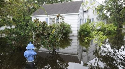
While authorities are recommending area residents avoid traveling on local roadways unless necessary, the Beaufort County Sheriff’s Office and the Beaufort County 911 Communications Center continues to update an online map showing potential hazards on Beaufort County roadways. To view the map, visit sartopo.com/m/QED0.
Remember to avoid downed power lines and to never drive through water.
More Hurricane Stories


SportsPlus
How to Watch the Bucks vs. Hornets Game: Streaming & TV Channel Info for February 5
The Milwaukee Bucks (26-22) will look to stop a four-game losing streak when they visit the Charlotte Hornets…
How to Watch Top 25 College Basketball Games – Wednesday, February 5
Top-25 teams will be in action across five games on Wednesday’s college basketball slate. That includes the Missouri…
Best Bets for NCAA Basketball Picks Against the Spread for Wednesday, February 5
The college basketball schedule on Wednesday, which includes the George Mason Patriots taking on the George Washington Revolutionaries,…
Top 25 College Hoops Picks Against the Spread – Wednesday, February 5
There are five games featuring a ranked team on Wednesday’s college basketball slate. Below, we provide against-the-spread picks…
NBA Best Bets: Bucks vs. Hornets Picks for February 5
The Milwaukee Bucks (26-22) take a four-game sllide into a road matchup with the Charlotte Hornets (12-35), losers…
-
Polls
 Loading ...
-
-