Temperature will determine snowfall totals
Published 6:27 pm Wednesday, February 19, 2020
- National Weather Service Newport/Morehead City
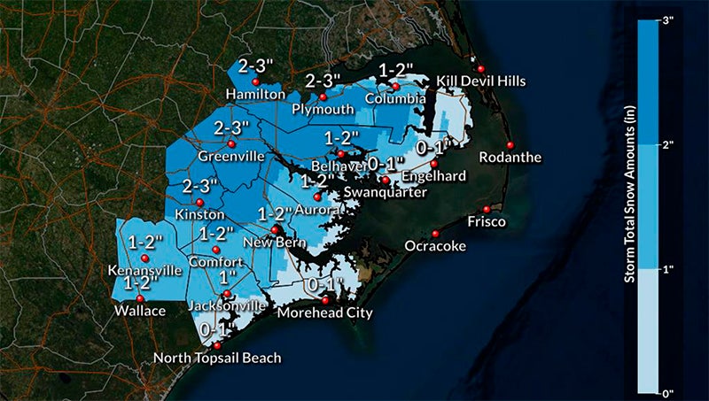
Eastern North Carolina is under a winter storm watch until Friday morning, with parts of Beaufort County potentially getting up to 3 inches of snow — more, if the temperature drops earlier.
Rain throughout the county is expected by noon Thursday, which will then change to snow at about 7 p.m. The heaviest snowfall is expected to occur between 8 p.m. and midnight, and accumulation of 2 to 3 inches is forecasted for areas east of Bath/Blounts Creek; 1 to 2 inches for areas west, according to the National Weather Service Newport/Morehead City office.
“Later Thursday, the confidence remains highest that the farther inland you live, the more likely it is that you’ll see snowfall,” meteorologist Erik Heden said during a update late Wednesday afternoon. “Closer to the coast will have a short window for snowfall so amounts will be less.”
Heden referred to the forecast as a “tight gradient between snow, perhaps a lot of snow and no snow.”
If the temperature drops more quickly than expected on Thursday night, a “worst-case scenario” could happen, coating much of region in 4 to 6 inches of snow. A low of 29 degrees is expected overnight Thursday in Washington. While all precipitation should be clear of Beaufort County by Friday morning and most accumulation is expected to be confined to elevated and/or grassy surfaces, there remains a potential for ice on roadways early Friday.
“Anything wet on the roadways will freeze up Friday morning,” Heden said.
The NWS Newport/Morehead City’s hazardous weather outlook warns of slippery road conditions that could impact the Friday morning commute. Secondary roads, bridges and overpasses are of particular concern.
Winds are expected to pick up by noon Thursday — for areas west of Bath/Blounts Creek, 10 mph sustained winds forecasted; 10-15 mph for areas east. Gusts of 25 mph are also possible during this time, as is localized flooding/inundation in areas prone to those conditions, according to an update from Beaufort County Emergency Services.
Heden said the storm has been a very difficult one to forecast.
“This is a very fluid forecast so please check back for updates. Our goal is to make adjustments and trend toward the most likely outcome as we get closer to the event,” he said.
Check www.thewashingtondailynews.com for weather updates Thursday.
More News


-
Polls
 Loading ...
-
-