Western Beaufort County to get a lot more snow
Published 11:32 am Thursday, February 20, 2020
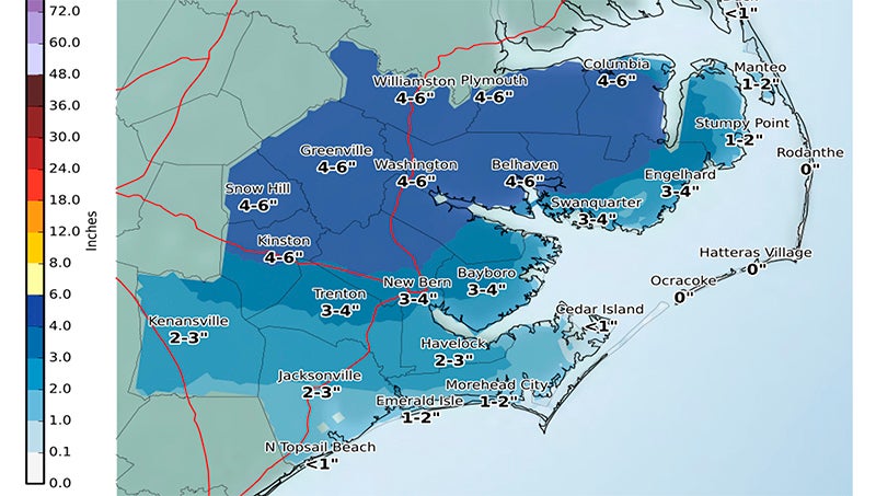
- (National Weather Service Newport/Morehead City)
A National Weather Service update this morning shows more snow for Beaufort County.
According to Beaufort County Emergency Services, county residents can expect to see the following today into tomorrow:
Rain will continue to move into our area and is expected to be widespread by noon. The rain is expected to transition to snow around 5 p.m., with accumulations beginning to occur around sunrise as ground temperatures approach freezing. Our heaviest snowfalls are expected to occur between 7 p.m. and 1 a.m., with most areas receiving 3 inches +/- during this time. Areas west of Bayview/Blounts Creek are expected to receive 4 – 6 inches of accumulation, with areas east forecasted to receive 3 – 4 inches. Areas north and west of U.S. Highway 264 and N.C. Highway 99 could receive localized higher amounts of 8” +/- depending on the track of heavier bands.
All precipitation should be clear of Beaufort County by sunrise Friday. Some melting is expected to occur on Friday as we reach highs near 38. However, temperatures are expected to drop into the low 20s Friday night, causing a refreeze of any remnants. This will make roadways and walking surfaces very treacherous though Friday night and the early morning hours of Saturday.
Areas west of Bath/Blounts Creek are expected to receive sustained NE winds at 10-15 mph beginning at noon Thursday. Areas east are expected to experience 15 – 20 mph winds. These winds will transition from NE to N through Friday morning, and are not expected to subside until late Friday night/Saturday morning. Gusts of 25 mph are possible during this time. Localized flooding/inundation is possible in areas prone to these conditions.
More Beaufort County


-
Polls
 Loading ...
-
-