Florence rain, wind abate, extreme flooding potential stays
Published 5:28 pm Wednesday, September 12, 2018

- (National Weather Service)
Hurricane Florence’s eventual impact on Beaufort County remains in question.
Wednesday afternoon, National Hurricane Center forecasters put Florence’s projected path on a more southwesterly course after a North Carolina landfall. If that track holds, Beaufort County will experience much less rain and wind than previously projected.
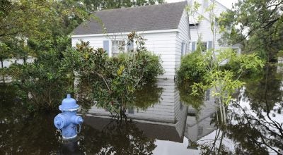
Extreme flooding, however, is very likely.
“We still expect 7 to 12 feet of storm surge,” said Carnie Hedgepeth, director of Beaufort County Emergency Services.
The storm surge remains as Florence is predicted to slow down and/or stall as it makes landfall early Friday. A slow-down would put Beaufort County in the northeast quadrant of the storm and hurricane-force winds funneling water up inland waterways. This, combined with rainfall across the region seeking an outlet will add up.
“Major river flooding expected across the area. Local and upstream rainfall will cause area rivers to flood. Many will reach flood stage as early as Friday, and will continue to rise well into next week. Given the generally slow rise of area rivers, most won`t crest until mid to late next week extending the impacts from this long duration flood event,” reads a situation overview from NWS. “Extreme storm surge impacts are expected with Hurricane Florence. Based on the current forecast, inundation of up to 9 to 13 feet above ground will be possible near and to the east of the center of the storm across the southern North Carolina coast, including the Pamlico
Sound, Neuse, and Pamlico rivers, as well as adjacent streams and bays. Moderate to significant storm surge flooding is expected over the northern coast with inundation of 3 to 6 feet above ground. A small shift in the track could change what locations may see the most significant inundation.”
While the flood threat remains strong, others may be backing off. Maximum sustained winds of 48 mph, with gusts up to 60 mph, are predicted for the area, as compared to earlier predictiosn of sustained 55 mph winds, gusting up to 85. Rainfall totals also decreased, but how much rain residents see may depend on where they’re located on the Pamlico River. The south side of the Pamlico is projected to get 10-15 inches of rain over the next seven days, while it’s estimated that most of the north side of the Pamlico will received between 6 and 10 inches.
Though the forecast has improved for Beaufort County, National Weather Center’s hurricane and storm surge warnings for the county remain. Until Florence is closer, it is impossible to pin down its exact path, which is why officials are continuing preparations with worse-case scenario in mind.
“The current storm, even though it’s changed its track, changes nothing of what we’re doing (to prepare), Hedgepeth said.
Beaufort County’s shelter at Washington High School opened at noon Wednesday and throughout the day, buses were picking up residents and busing them to the shelter, and emergency services staff assisted special-needs patients with finding transport to Cherry Hospital in Goldsboro.
Hedgepeth said many have heeded the county’s voluntary evacuation for the entire county, a mandatory evacuation for those living in low-lying, flood-prone areas.
“I know people have left because they have contacted us or left some message that they are leaving the county,” Hedgepeth said. “Others we know have told us that they are staying in place and a lot have eagerly awaited the opening of the shelter.”
Hedgepeth said emergency services will continue to put out information through the media and social media and asked that all Beaufort County residents and visitors heed those notices.
“Our biggest thing is: even though the storm track has changed do not lessen your guard. It can change back,” Hedgepeth said. “We still expect flooding to happen, we still expect wind problems, and we still expect transportation and utility issues. “We’re not trying to put the public in a panic. We’re just trying to be realistic.”
More Hurricane Stories


SportsPlus
College Basketball Picks Against the Spread: AAC Games Today, December 23
In one of the compelling matchups on the AAC college basketball schedule on Monday, the Murray State Racers…
Rockets vs. Hornets Prediction & Picks: Line, Spread, Over/Under – December 23
The Charlotte Hornets (7-21) will look to break a four-game losing streak when they host the Houston Rockets…
Buy Tickets for Carolina Hurricanes vs. Nashville Predators on December 23
Martin Necas and Filip Forsberg are two of the most exciting players to keep an eye on when…
NBA Best Bets: Rockets vs. Hornets Picks for December 23
The Charlotte Hornets (7-21) are 5.5-point underdogs as they attempt to stop a seven-game home losing streak when…
Sebastian Aho Player Prop Bets for the Hurricanes vs. Predators Game – December 23
Sebastian Aho will be in action when the Carolina Hurricanes and Nashville Predators face off on Monday, December…
-
Polls
 Loading ...
-
-