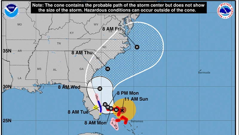
National Weather Service Dorian update, 11 a.m.
Published 11:16 am Sunday, September 1, 2019

- (NATIONAL HURRICANE CENTER)
Air Force and NOAA reconnaissance planes penetrated the distinct eye of Dorian, and found that the hurricane has become extremely intense with a stadium effect in the eye. The NOAA plane reported a peak flight-level wind of 159 kt, while the SFMR from both planes have measured winds between 155 and 170 kt. A dropsonde from the NOAA plane measured a wind gust of 176 kt at the surface. A blend of these measurements yield to an initial intensity of 155 kt, making Dorian the strongest hurricane on record in the northwestern Bahamas.
For the next few days, Dorian should experience some fluctuations in intensity, and in addition to eyewall replacement cyclone, the interaction with the northwestern Bahamas should weaken the hurricane slightly. After 3 days, as Dorian moves northward along or offshore of southeast United States coast, the shear is forecast to increase, resulting in a more distinct gradual weakening.
Reconnaissance plane and satellite fixes indicate that Dorian, as anticipated, has slowed down and is moving toward the west or 270 degrees at 6 kt. The steering currents are collapsing and Dorian is expected to slow down even more, prolonging its catastrophic effects in the northwestern Bahamas. The NHC forecast calls for a slow west to west-northwest motion during the next 48 hours, with a turn to the north and an increase in forward speed as the mid-level trough along the eastern United States deepens and becomes the dominant steering feature. The current forecast is only a few miles west of the previous one and is basically on top of the multi-model consensus. Both the deterministic and consensus tracks have shown the usual variability to the right or to the left from run to run, but the overall trend is for the hurricane to turn northward offshore but very close to the Florida peninsula.
Given the uncertainty in the track forecast and the anticipated increase in size of the hurricane, a Hurricane Watch and Storm Surge Watch have been issued for a portion of the east Florida coast. It is emphasized that although the official track forecast does not show landfall, users should not focus on the exact track. A small deviation to the left of the track could bring the intense core of the hurricane its dangerous winds closer to or onto the coast.
Key Messages:
- A prolonged period of catastrophic winds and storm surge will affect the Abaco Islands today. Everyone there should take immediate shelter and not venture into the eye. These catastrophic conditions are likely on Grand Bahama Island later today or tonight, and efforts to protect life and property there should be rushed to completion.
- Storm surge and hurricane watches and tropical storm warnings are in effect for portions of the Florida east coast. Life-threatening storm surge and dangerous hurricane-force winds are possible along portions of the Florida east coast through mid-week, as only a slight deviation to the left of the official forecast would bring the core of Dorian near or over the coast. Residents should listen to advice given by local emergency officials.
- There is an increasing likelihood of strong winds and dangerous storm surge along the coasts of Georgia, South Carolina, and North Carolina later this week. Residents in these areas should continue to monitor the progress of Dorian.
- Heavy rains, capable of producing life-threatening flash floods, are possible over northern portions of the Bahamas and coastal sections of the southeast and lower mid-Atlantic regions of the United States through late this week.


